New Gradient was awarded a UK Space Agency Climate Services Call 3 grant to develop geospatial AI for woodland digital Measurement, Reporting and Verification (dMRV). The six-month project, running from September 2025 to February 2026, built a complete pipeline from raw Earth observation data to per-tree carbon estimates, advancing woodland dMRV capability from TRL 2 to TRL 4. All four contractual milestones were delivered on time and within budget.
Woodland carbon verification doesn’t scale
The UK Woodland Carbon Code requires baseline surveys and periodic monitoring of tree density, species composition, canopy structure, and biomass for every registered project. Current practice relies on manual field surveys: expensive, slow, inconsistent across sites, and fundamentally limited in coverage. With private capital flowing into woodland restoration to meet corporate net-zero commitments, the market needs measurement infrastructure that can cover thousands of hectares at audit-grade accuracy without sending ecologists to every site.
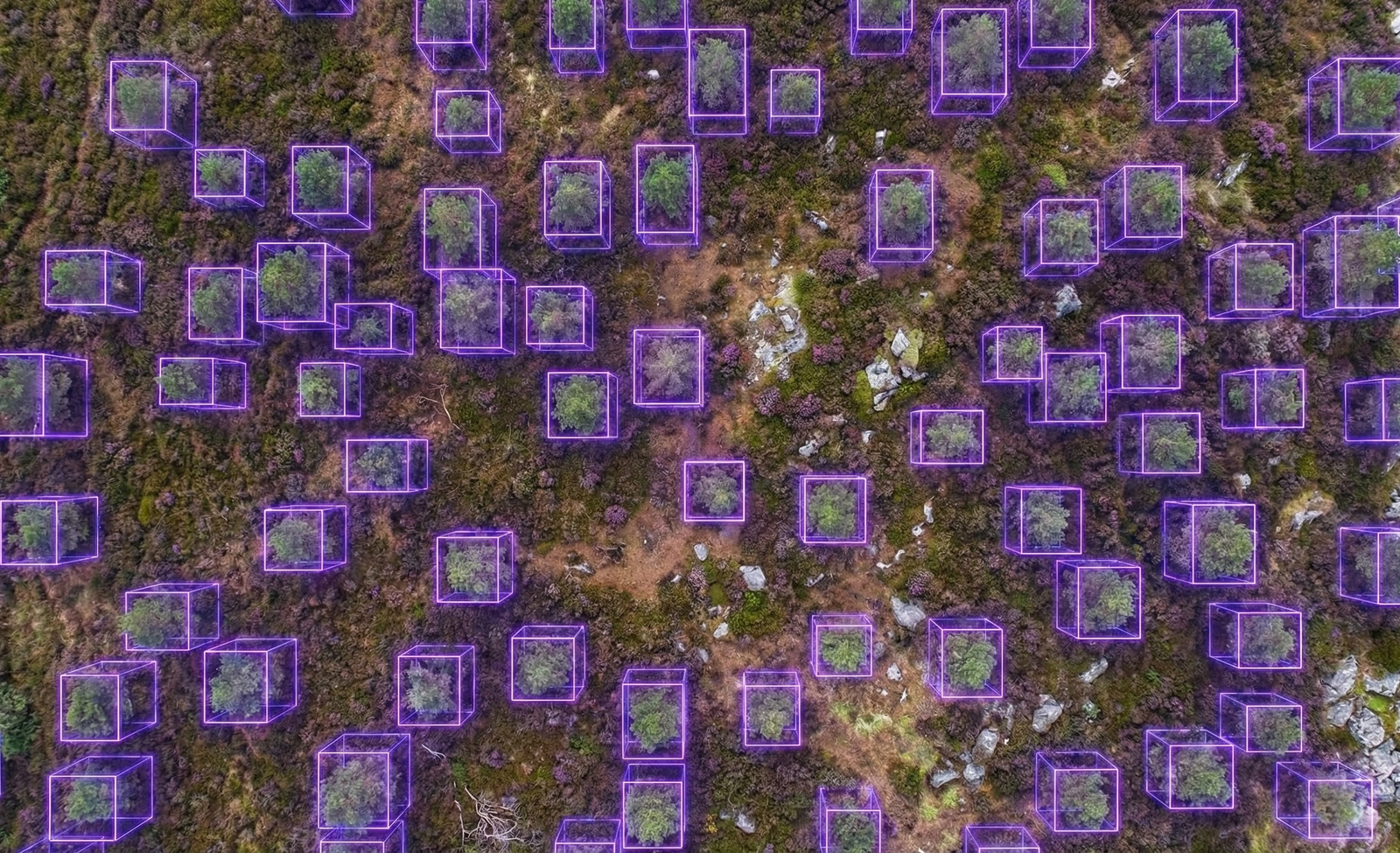
The challenge is that woodland measurement is not a single task. Estimating above-ground biomass and carbon sequestration requires multiple intermediate variables: how many trees are present, where each crown boundary falls, what species each tree is, and how tall the canopy stands. Each variable feeds into allometric equations that convert physical measurements into carbon estimates. Automating this requires not one model but an integrated pipeline of specialist models, each validated independently and producing interpretable outputs that verifiers can inspect.
A foundation model architecture for woodland measurement
Under the UKSA grant, we developed a self-supervised foundation model pretrained on 1.8 million paired RGB and Digital Surface Model tiles covering UK aerial and satellite imagery. The model learns rich representations of woodland structure, texture, and height without requiring any labelled training data, using a masking-based pretraining strategy that forces the network to understand spatial context from partial observations. This single pretrained backbone then serves as the starting point for every downstream measurement task.
We fine-tuned four expert models from this shared backbone, each addressing one variable in the Woodland Carbon Code measurement chain. A tree counting model trained on over one million annotated trees from seven international datasets generalises across dense canopy, sparse brushland, urban trees, plantations, and winter deciduous woodland. A crown segmentation model delineates individual tree crown boundaries, achieving AP@50 of 72.3% and outperforming published baselines on standard benchmarks. A species classification model focuses attention within each predicted crown, classifying conifer versus broadleaved at 96.8% accuracy with a conservative error profile that underestimates rather than inflates biomass. Canopy height is derived by fusing predicted crown polygons with national LiDAR products from the Environment Agency and Scottish Remote Sensing Portal, producing physically grounded, survey-comparable per-tree height measurements.
A biomass estimation methodology was developed and benchmarked against public datasets, validating the approach for satellite-scale above-ground biomass prediction and identifying the route to full operational performance.
The entire pipeline was built to be modular: each expert model can be inspected, validated, updated, or replaced independently. Every intermediate output is auditable, which is critical for carbon market credibility where verifiers need to understand not just the final number but how it was derived.
From UKSA research to commercial woodland dMRV
The capability developed under this UKSA grant is being commercialised through Calterra, a joint venture between New Gradient and Caledonian Climate Partners. Calterra is already operational in peatland dMRV with existing relationships across land managers, compliance bodies, and project developers. The woodland pipeline extends Calterra’s offering to a dual-ecosystem dMRV capability covering both the Woodland Carbon Code and the Peatland Code, built on the same foundation model architecture.
Products in development include a WCC baselining tool for automated pre-planting metrics, an annual monitoring module for canopy change detection, and a portfolio dashboard for multi-site carbon delivery tracking. The foundation model and data pipelines are extensible to finer species classification, below-ground carbon fractions, and uncertainty quantification for financial audit use. The shared backbone approach means each new capability builds on validated infrastructure rather than starting from scratch.